![](/images/other/stat-length.png)
![Excursión Esquí de fondo La Plagne-Tarentaise - La Chaille. col à l'ouest du Rocher st Laurent - Photo](https://media.geolcdn.com/t/1900/400/a890abcf-139f-4fa9-a31e-dd584261d663.jpg&format=pjpeg&maxdim=2)
La Chaille. col à l'ouest du Rocher st Laurent
nadd73
Usuario GUIDE
![Longitud](/images/other/stat-length.png)
Longitud
13,9 km
![Altitud máxima](https://static1.geolcdn.com/siteimages/upload/files/1508320355ic_sort_altitude_max_24dp.png)
Altitud máxima
2420 m
![Desnivel positivo](https://static1.geolcdn.com/siteimages/upload/files/1508320355ic_sort_den_pos_24dp.png)
Desnivel positivo
1112 m
![Km-Effort](/images/other/stat-length.png)
Km-Effort
29 km
![Altitud mínima](https://static1.geolcdn.com/siteimages/upload/files/1508320355ic_sort_altitude_min_24dp.png)
Altitud mínima
1411 m
![Desnivel negativo](https://static1.geolcdn.com/siteimages/upload/files/1508320355ic_sort_den_neg_24dp.png)
Desnivel negativo
1111 m
![Boucle](https://static1.geolcdn.com/siteimages/upload/files/16400158638029165_repeat_loop_refresh_sync_direction_icon.png)
Boucle
Sí
Fecha de creación :
2020-01-13 08:09:48.172
Última modificación :
2020-01-13 17:41:54.697
![Esquí de fondo](https://static1.geolcdn.com/sitytour/trail-icons/503.png)
6h38
Dificultad : Fácil
![Escanee este código QR para abrir la excursión en la aplicación SityTrail](https://capi.geolives.com/qq0zvz2zws4bq2lad0pu/sitytour/trails/2304719/qr.png?size=200)
Aplicación GPS de excursión GRATIS
A propósito
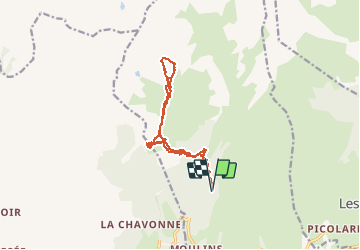
Ruta Esquí de fondo de 13,9 km a descubrir en Auvergne-Rhône-Alpes, Saboya, La Plagne-Tarentaise. Esta ruta ha sido propuesta por nadd73.
Descripción
Départ : Les Pars
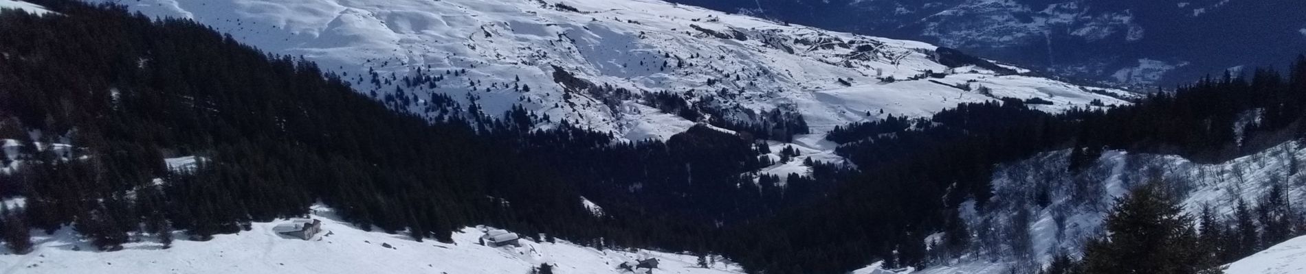
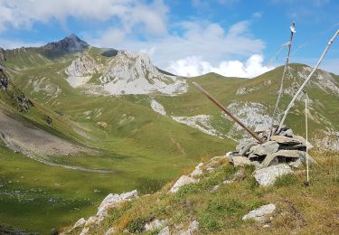
Nous sommes allés à la Chaille pour voir le couloir Nord.
Localización
País:
France
Región :
Auvergne-Rhône-Alpes
Departamento/provincia :
Saboya
Municipio :
La Plagne-Tarentaise
Localidad:
La Côte-d'Aime
Salida:(Dec)
Salida:(UTM)
318327 ; 5051310 (32T) N.
Comentarios
Excursiones cerca
![Excursión Senderismo La Plagne-Tarentaise - Les Fours- belle rando facile - Photo](https://media.geolcdn.com/t/375/260/ce194bd9-f6a3-46bc-be1d-c29d53223d34.jpg&format=jpg&maxdim=2)
![Senderismo Senderismo](https://static1.geolcdn.com/sitytour/trail-icons/101.png)
Les Fours- belle rando facile
Senderismo
Fácil
(1)
La Plagne-Tarentaise,
Auvergne-Rhône-Alpes,
Saboya,
France
![](/images/other/stat-length.png)
8,6 km | 12 km-effort
2h 55min
![](https://static1.geolcdn.com/siteimages/upload/files/16400158638029165_repeat_loop_refresh_sync_direction_icon.png)
Sí
![Excursión Senderismo La Plagne-Tarentaise - Les Fours - Photo](https://media.geolcdn.com/t/375/260/ext.jpg?maxdim=2&url=https%3A%2F%2Fservices.sitytrail.com%2FGeolivesWS%2FDownloadMedia.ashx%3FTrailID%3D962720%26Media%3Dfix__20180506164939.jpg)
![Senderismo Senderismo](https://static1.geolcdn.com/sitytour/trail-icons/101.png)
Les Fours
Senderismo
Fácil
(2)
La Plagne-Tarentaise,
Auvergne-Rhône-Alpes,
Saboya,
France
![](/images/other/stat-length.png)
8,4 km | 11,7 km-effort
2h 50min
![](https://static1.geolcdn.com/siteimages/upload/files/16400158638029165_repeat_loop_refresh_sync_direction_icon.png)
Sí
![Excursión Senderismo Aime-la-Plagne - 2024-09-08 Marche Tour Beaufortain Refuge Coire vers Refuge Presset - Photo](https://media.geolcdn.com/t/375/260/b0c8e42e-e06a-4d0e-aaaf-41f5a8616494.jpg&format=jpg&maxdim=2)
![Senderismo Senderismo](https://static1.geolcdn.com/sitytour/trail-icons/101.png)
2024-09-08 Marche Tour Beaufortain Refuge Coire vers Refuge Presset
Senderismo
Muy difícil
Aime-la-Plagne,
Auvergne-Rhône-Alpes,
Saboya,
France
![](/images/other/stat-length.png)
13,6 km | 26 km-effort
5h 48min
![](https://static1.geolcdn.com/siteimages/upload/files/16400158638029165_repeat_loop_refresh_sync_direction_icon.png)
No
![Excursión Senderismo La Plagne-Tarentaise - 73 Tarentaise Col du Mont Rosset Refuge de la Balme-Col et Charbonnière Lac de la Portette - Photo](https://media.geolcdn.com/t/375/260/ext.jpg?maxdim=2&url=https%3A%2F%2Fstatic1.geolcdn.com%2Fsiteimages%2Fupload%2Ffiles%2F1553511878bg_sport_marche.png)
![Senderismo Senderismo](https://static1.geolcdn.com/sitytour/trail-icons/101.png)
73 Tarentaise Col du Mont Rosset Refuge de la Balme-Col et Charbonnière Lac d...
Senderismo
Muy difícil
(1)
La Plagne-Tarentaise,
Auvergne-Rhône-Alpes,
Saboya,
France
![](/images/other/stat-length.png)
14,5 km | 31 km-effort
6h 56min
![](https://static1.geolcdn.com/siteimages/upload/files/16400158638029165_repeat_loop_refresh_sync_direction_icon.png)
Sí
![Excursión Esquí de fondo Aime-la-Plagne - le Crêt du Rey face Est - Photo](https://media.geolcdn.com/t/375/260/85030d7c-824d-4fcc-8e4c-058138221f73.jpg&format=jpg&maxdim=2)
![Esquí de fondo Esquí de fondo](https://static1.geolcdn.com/sitytour/trail-icons/503.png)
le Crêt du Rey face Est
Esquí de fondo
Difícil
Aime-la-Plagne,
Auvergne-Rhône-Alpes,
Saboya,
France
![](/images/other/stat-length.png)
18,7 km | 36 km-effort
8h 21min
![](https://static1.geolcdn.com/siteimages/upload/files/16400158638029165_repeat_loop_refresh_sync_direction_icon.png)
Sí
![Excursión Senderismo Aime-la-Plagne - Balcons de Granier - Photo](https://media.geolcdn.com/t/375/260/ext.jpg?maxdim=2&url=https%3A%2F%2Fstatic1.geolcdn.com%2Fsiteimages%2Fupload%2Ffiles%2F1553511878bg_sport_marche.png)
![Senderismo Senderismo](https://static1.geolcdn.com/sitytour/trail-icons/101.png)
Balcons de Granier
Senderismo
Fácil
(2)
Aime-la-Plagne,
Auvergne-Rhône-Alpes,
Saboya,
France
![](/images/other/stat-length.png)
7,3 km | 12,6 km-effort
2h 48min
![](https://static1.geolcdn.com/siteimages/upload/files/16400158638029165_repeat_loop_refresh_sync_direction_icon.png)
Sí
![Excursión Raquetas de nieve Aime-la-Plagne - combe benite - Photo](https://media.geolcdn.com/t/375/260/ext.jpg?maxdim=2&url=https%3A%2F%2Fstatic1.geolcdn.com%2Fsiteimages%2Fupload%2Ffiles%2F1524743153raquette.jpg)
![Raquetas de nieve Raquetas de nieve](https://static1.geolcdn.com/sitytour/trail-icons/504.png)
combe benite
Raquetas de nieve
Difícil
(1)
Aime-la-Plagne,
Auvergne-Rhône-Alpes,
Saboya,
France
![](/images/other/stat-length.png)
5,3 km | 16,4 km-effort
2h 56min
![](https://static1.geolcdn.com/siteimages/upload/files/16400158638029165_repeat_loop_refresh_sync_direction_icon.png)
No
![Excursión Senderismo Aime-la-Plagne - Mont Coin - Photo](https://media.geolcdn.com/t/375/260/4f563390-2587-42f5-8996-ce783b07d0a6.jpg&format=jpg&maxdim=2)
![Senderismo Senderismo](https://static1.geolcdn.com/sitytour/trail-icons/101.png)
Mont Coin
Senderismo
Medio
Aime-la-Plagne,
Auvergne-Rhône-Alpes,
Saboya,
France
![](/images/other/stat-length.png)
17 km | 32 km-effort
6h 59min
![](https://static1.geolcdn.com/siteimages/upload/files/16400158638029165_repeat_loop_refresh_sync_direction_icon.png)
Sí
![Excursión Senderismo Aime-la-Plagne - Beaufortain: Autour de La Pierra Menta: J6 - Ref. de La Coire - Pk Laval - Photo](https://media.geolcdn.com/t/375/260/85d2bac9-c38a-45a8-9da1-d0cde71c6974.jpg&format=jpg&maxdim=2)
![Senderismo Senderismo](https://static1.geolcdn.com/sitytour/trail-icons/101.png)
Beaufortain: Autour de La Pierra Menta: J6 - Ref. de La Coire - Pk Laval
Senderismo
Medio
Aime-la-Plagne,
Auvergne-Rhône-Alpes,
Saboya,
France
![](/images/other/stat-length.png)
10,4 km | 17 km-effort
3h 21min
![](https://static1.geolcdn.com/siteimages/upload/files/16400158638029165_repeat_loop_refresh_sync_direction_icon.png)
No